“The Watchet link” on the Coleridge Way
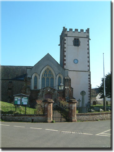
At Sampford Brett Church you will leave the Coleridge Way. Pass the Church on your right and walk along the lane towards the ‘Give Way’ sign. When you reach the main A358 (Taunton to Williton road) cross this busy route to the Quantock Service Station garage with great care. From this point you join the Macmillan Way West footpath signed ‘footpath to Williton’.
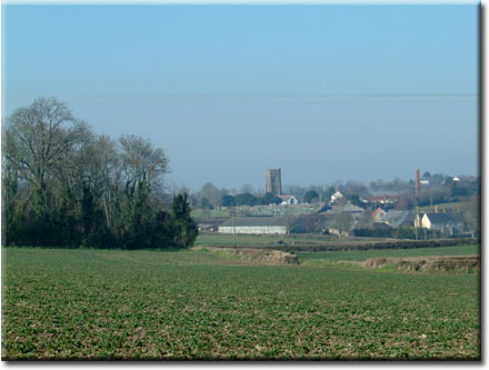
Continue along this track to the left of the garage and pass beside cottages to enter a farm yard. Walk between barns and buildings climbing a stile to take a broad track that leads above the fields on your right and with the meandering Doniford River below. Climb the stile at the end of the lane and enter a field on your left passing through more fields. Your path is quite well defined and ahead of you are the two prominent radio masts at the Tropiquaria Centre with the Brendon Hills beyond.
Proceed through the fields with the hedge on your right until you the reach a narrow metal kissing gate. Turn right and after approx 30 paces, at the large stone gateway of a house, leave the Macmillan Way West * and turn right to pass through a small gateway and proceed along the footpath which takes you between the fenced edge of a field and the stream on your left. Cross a little bridge and pass between houses 63 and 65 Townsend. Turn right and continue until you reach the A39 opposite Sir Gilbert Scott Court (formerly the old Williton Workhouse). Cross the A39 with care and turn to your right and then immediately left down a broad track beside the development. At this point you join the West Somerset Coast Path as indicated by the ammonite shell symbol.
Walk along the full length of this broad track which can become very muddy during wet weather. When the track ends at a field gate, turn left following the ammonite symbol and the yellow arrow to pass through a wooden kissing gate. Go through a second kissing gate and when your path descends to join another track, turn right. Cross the stream via a narrow stone bridge to reach the road and turn left. After 40 paces at the stile on the right hand side of the road, enter the field and walk along the left hand edge of the field with a small stream beside it. Exit the field onto a broad grassy track which leads to the road. Turn right and then after a short distance turn right again onto a small tarmaced lane which climbs steadily towards a wood. The lane narrows at the brow of the hill and then descends between two fields until you reach a wooden gate.
Ahead of you is the town of Watchet with the Bristol Channel beyond. The path exits between garden hedges onto Woodland Road, cross the road and walk down the hill. After passing the playing field on your right, take the third right into Flowerdale Road.
At the end of the road turn left and continue along Liddymore Road, which sports two small supermarkets, a café and two take-aways, to the junction with Doniford Road. Cross carefully and continue down Goviers Lane to cross the West Somerset Railway line. Descend the stone steps to cross Harbour Road and walk along the Esplanade. (3 miles from Sampford Brett)
With the marina on your right walk across the Esplanade, but maybe pause awhile and take some time to enjoy this quaint little town.
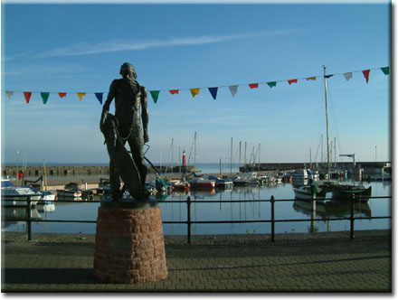
Midway along the Esplanade is the Watchet Tourist Office whose volunteer staff have the town at heart, providing much valuable and interesting local information about the area. Note the statue of Yankee Jack (Jack Short) a famous sailor and shanty man of Watchet, with a long and fascinating history, more details of whom will be revealed by a visit the museum at the far end of the Esplanade.
Further
along the Esplanade is the statue of The Ancient Mariner - both this and
the statue of Yankee Jack were commissioned by the Market House Museum
Committee to commemorate two very special characters. “The Rime
of the Ancient Mariner” written by Samuel Coleridge (the same who
lived for a while in Nether Stowey and after whom the Coleridge Way was
named), stands boldly and reminds us of the poet’s visits to Watchet
where, it is said, that he penned some of this somewhat lengthy poem –in
the Bell Inn! A visit to the museum is free and local residents who steward
the museum would be more than happy to chat about Watchet and its history.
A detour along Swain Street (formerly Swine Street), the length of which
offers gift shops, cafes and restaurants, a post office, paper shop, hardware
shop, clothing outlets, a picture gallery, antiques, flower shop and a
chemist, will do much to encourage delay for browsing and shopping.
With
time running out return along Swain Street to the Market House Museum
and pick up your route again.
Passing the Market House Museum building on your right and the Bell Inn on your left, walk along Market Street to ‘the Basin’ (a tidal pool) on your left turning left to follow the fingerpost signed ‘Old Mineral Line’. Here you leave the West Somerset Coast Path and head towards the Star Inn. Pass to the left of the inn and walk along the narrow footway with the Washford River on your left. Do not cross the pack-horse pedestrian bridge but continue until you reach the roadway Turn right and walk along Whitehall and, where the road bends to the left, take the right hand track signed ‘Public footpath only, no unauthorised vehicles’ with a wooden post signed ‘Washford’. This level footpath (originally the track of the old Mineral Railway) is a delightful walk of approximately 1.5 miles , between the Washford River, and the West Somerset Railway (the longest privately run “heritage” railway in England).
Across the fields to the left you can see Kentsford Farm House, the oldest secular building in Watchet and you could, if time permitted, watch for a steam train at the Kentsford Crossing.
The Old Mineral Line track ends at the school playing field. Go through the five bar gate at the far end and onto a rough track to reach the lane. Turn right and walk to the ‘T’ junction, cross the road to take the narrow footpath immediately ahead of you again following beside the railway line until you reach the car park at the Washford Hotel.
Keeping to the same side of the road turn left and follow the pavement until you reach the bus shelter. Cross the road here with extreme care (this is a very busy holiday route) and make your way past the garage to take the rough track to your right and enter the field over a wooden stile beside a metal farm gate.
Keeping the hedge and then the wire fence on your left, make your way up through the field, over three stiles climbing steadily through three more fields with fine views of the Brendon Hills ahead, and Exmoor over your right shoulder. Your path eventually joins a wide farm track. Make your way along this track until you reach the lane at a ‘T’ junction. Turn left down the steep hill with high banks on either side and at a further ‘T’ junction, turn right towards the village of Roadwater and walk approximately ¾ mile through this ‘extended’ village.
Pass the Roadwater Village Hall and Post Office and stores and, ignoring the two lanes to your left, continue until you reach the Valiant Soldier public house on your right where you rejoin the Coleridge Way.
Total
approx 7 miles
3.5 hours
©James Nicholas & Sue Upstone 2007
*
- Ref Walk 4 Watchet Wyndham – “Watchet Around & About”
(a book of 10 walks which include parts of this walk)
** - Ref Walk 7 Watchet Mineral Line – “Watchet Around &
About” see the website below for details
www.walkingwestsomerset.co.uk
Telephone: 01984 631925 or 01984 631660